


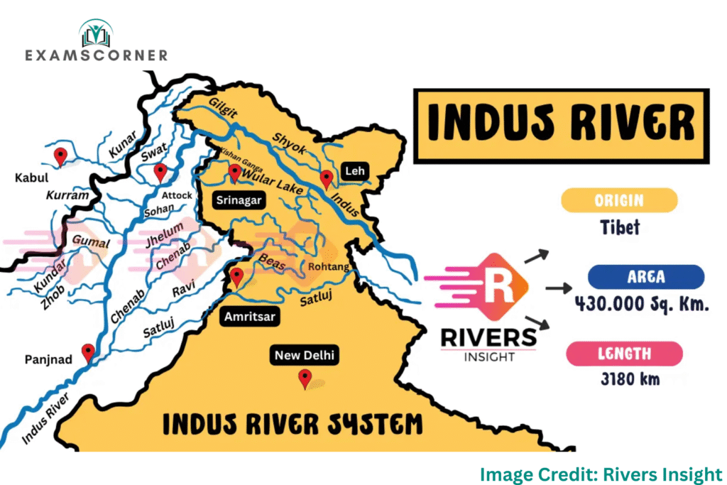
The Indus River, known as Sindhu River in ancient times, is one of the longest rivers in the world, stretching approximately 3,180 kilometers. Originating in the Tibetan Plateau, it flows through China, India, and Pakistan, playing a crucial role in agriculture, hydroelectric power, and livelihoods for millions.
This article explores the Indus River system, its tributaries, geographical features, major dams, and river maps, providing a comprehensive guide for students, researchers, and geography enthusiasts.

Geographical Features of the Indus River
Origin and Course of the Indus River
The Indus River originates near Lake Mansarovar on the Tibetan Plateau, formed by the confluence of two major tributaries:
- Sengge Zangbo (Shiquan River)
- Gar Tsangpo
From Tibet, the river flows northwest into Ladakh (India), then through Pakistan, passing the Himalayan, Karakoram, and Sulaiman mountain ranges, before emptying into the Arabian Sea near Karachi.
Indus River Basin & Key States
The Indus River Basin spans across:
- China (Tibet)
- India (Jammu & Kashmir, Himachal Pradesh, Punjab)
- Pakistan (Punjab, Sindh, Khyber Pakhtunkhwa)
The river supports agriculture, drinking water, and hydroelectric power in these regions.
5 Major Tributaries of the Indus River
The Indus River system is fed by several key tributaries, which enhance its water flow and support irrigation and power generation.
1. Jhelum River
- Origin: Verinag Spring, Jammu & Kashmir
- Length: 725 km
- Key Features:
- Flows through Srinagar and enters Pakistan
- Mangla Dam (Pakistan) regulates water flow
2. Chenab River
- Origin: Himachal Pradesh
- Length: 1,080 km
- Key Features:
- Major hydropower projects like Baglihar Dam
- Vital for Punjab’s agriculture
3. Ravi River
- Origin: Himalayas (India)
- Length: 720 km
- Key Features:
- Thein Dam helps in irrigation and power generation
- Flows into Pakistan’s Punjab region
4. Beas River
- Origin: Beas Kund, Himalayas
- Length: 470 km
- Key Features:
- Pong Dam supports irrigation and electricity
- Flows entirely within India (Himachal Pradesh & Punjab)
5. Satluj River
- Origin: Tibet (China)
- Length: 1,450 km
- Key Features:
- Bhakra Nangal Dam (India’s largest dam)
- Critical for Punjab’s agriculture
Left & Right Bank Tributaries of the Indus River
| Left Bank Tributaries | Right Bank Tributaries |
|---|---|
| Jhelum River | Shyok River |
| Chenab River | Gilgit River |
| Ravi River | Hunza River |
| Beas River | Swat River |
| Satluj River | Kunar River |
| Zaskar River | Kurram River |
| Suru River | Kabul River |
| Soan River |
Important Dams on the Indus River System
| Dam Name | River | Location |
|---|---|---|
| Bhakra Dam | Satluj | Himachal Pradesh, India |
| Chamera Dam | Ravi | Himachal Pradesh, India |
| Pong Dam | Beas | Himachal Pradesh, India |
| Baglihar Dam | Chenab | Jammu & Kashmir, India |
| Uri Dam | Jhelum | Jammu & Kashmir, India |
| Salal Dam | Chenab | Jammu & Kashmir, India |
| Dul Hasti Dam | Chenab | Jammu & Kashmir, India |
| Thein Dam | Ravi | Punjab, India |
These dams play a crucial role in flood control, irrigation, and hydroelectric power generation.
Indus River Map & Route
To understand the Indus River’s course, refer to the river map below:
Key Highlights of the Indus River Map:
- Source: Tibetan Plateau (China)
- Flow Path: China → Ladakh (India) → Pakistan → Arabian Sea
- Major Cities Along the River: Leh (India), Sukkur (Pakistan), Hyderabad (Pakistan), Karachi (Pakistan)
For a detailed waterways map, check:
Significance of the Indus River System
- Agriculture: Supports Punjab’s fertile plains (India & Pakistan)
- Hydropower: Major dams generate electricity
- Historical Importance: Cradle of the Indus Valley Civilization
- Transportation: Used for waterways navigation in some regions
Map of the Indus River System
FAQs on the Indus River System
1. What is the other name of the Indus River?
The Indus River is also called Sindhu River in ancient texts.
2. Which is the largest dam on the Indus River?
The Bhakra Nangal Dam on the Satluj River is one of the largest.
3. Does the Indus River flow through Karnataka?
No, the Indus flows through Tibet, India (J&K, Himachal, Punjab), and Pakistan.
4. Where can I find an India map showing rivers?
You can explore India river maps on government or geographical survey websites.
Conclusion
The Indus River system is a lifeline for millions in India, Pakistan, and China. With its major tributaries, dams, and vast basin, it remains crucial for agriculture, power, and economy. Understanding its route map, waterways, and tributaries helps in appreciating its ecological and historical importance.